West Africa Trip Report 2011
MAPA Project Trip to the Heart of West Africa 2011
As darkness fell I was scrabbling around on the floor underneath the 105 trying to locate the origin of the high flowing fuel leak emanating from the main tank. With the beam from my Petzl head torch I could see the stream of petrol arcing like an ornamental fountain away from the top of the tank, this was going to be tough to get to but even tougher to try and remedy a repair.
Moments earlier we had filled up both fuel tanks after arriving on vapour, to add complexity we were having engine trouble which was causing a lack of power and eventual halt for 5 minutes every 5 minutes. We were 200Km south of Oaugadougou in Burkina Faso, less than 5 days in. This was not how I envisaged my five weeks mapping National Parks for the MAPA Project.
Background
The MAPA Project (Mapping Africa’s Protected Areas) has been doing its thing around the south and east of the continent whilst I was busy driving around Morocco in 2008. It wasn’t until Late August 2010 that I spotted a thread on the Expedition Portal notifying that they were doing the same for West Africa and looking for volunteers. I had not spotted the update for a number of months, but thought it worth getting an application in. This time around MAPA decided entrants needed to be in pairs to ensure compatibility. This being the case I needed a good friend who could take five weeks off with little notice, wanted to travel through some of the most politically unstable and corrupt countries of the world working voluntarily at the same time. Bush mechanics, a foreign tongue, medical knowledge, 4×4 driving skills, technical savvy and a thirst for outdoor living were all desirable extras.
Emails went around some of my more experienced overland travelling friends but the response was a disappointing and resounding no. I put the trip out of my mind. Two weeks later I got a call from my friend Peter who we met in Morocco, he had reconsidered. We promptly put our applications in and weeks went by without even a notification. A quick email to March Turnbull (MAPA Director) proved he had not only received our applications, but put us on the first reserve list. “Is that OK?” Absolutely! A month went by, an opportunity came up, but Peter Was in Namibia with his 110! we had to say no. By the end of November something else had come up, MAPA had a 3 month stint to fill. We put in for mid-March to mid-April, Peter was back and it straddled the holiday year for us both meaning time off would be easier… or so I thought. Routes were planned, flights looked at, but celebration didn’t last long as Peter soon found out he could not get the full five weeks off work. It was complicated, we looked at our options but there was no solution, I had to find someone else… fast.
By February the project was coming to a close as teams had been mapping east to west from Cameroon. The troubles in the Ivory Coast before Christmas changed the route as it removed a vital link south along the coast, parks in northern Mali and Niger were crossed off the list due to the recent kidnappings and murders of westerners by AQIM (Al-Quaeda Organisation in the Islamic Maghreb). Coupled with the possibility of not getting into Guinea due to land border closures (ongoing military coup) MAPAs time in West Africa was getting shorter. With the other team two weeks ahead of us it was decided that they would route to Guinea (if possible) through Sierra Leone and onto Liberia, making their way back to Guinea Bissau and through to Dakar in Senegal, the final meeting point. Our countries would be Burkina Faso, Mali, Senegal and possibly Gambia. We would see how we got on. With only five weeks to go and nobody lined up I honestly didn’t think I would be going anywhere. Discussions with a friend at work showed he was keen, but quitting your long term employment for a short duration volunteer project is a bold move. Luckily one that Simon was happy to make. The four week countdown vanished and before we knew it we had our Visas, yellow fever certificates, flight tickets and I was bidding farewell to Lisa on the tarmac of Bristol Airport… our adventure had begun.
Touching down in Ouaga (Ouagadougou) 1630 the air temperature on opening the cabin doors was a relentless 42°c. Checking our visa and yellow fever certificate were in order and a quick rustle of the bags we cleared customs. The airport lies on the edge of the city just a ten minute taxi ride from the centre. From the air Ouaga is a small capital city, dusty, dirty and very busy, much what we expected. Our accomodation was the Hotel Delwende where we made plans to pick up the truck and start organising things for the coming five weeks of mapping.
")
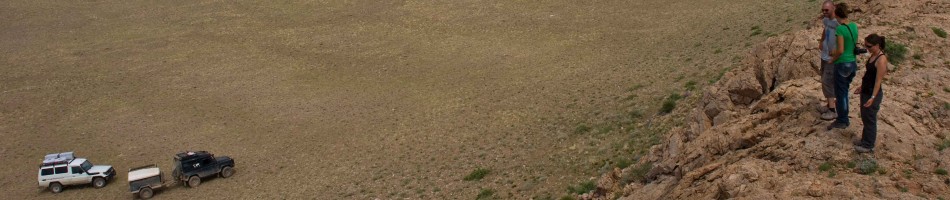
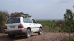
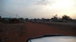
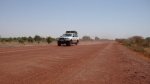
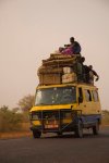
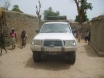
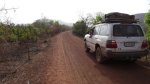
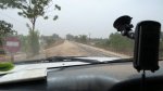
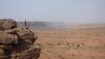
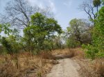
Cruising out of ‘Ouaga
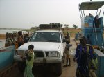
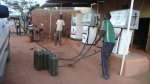
Our truck for was a 2000MY Toyota Land Cruiser 105, the stripped out bare version of the rest of world (ROW) 100 series. South African registered right hand drive it unfortunately had the 4.5L straight 6 petrol engine (1FZ for ‘yota aficionados). Thirsty? How does 14mpg (5km/litre) sound? Not to worry we had 2 fuel tank topping 120 litres and a further three nato jerry cans. Fuel worries aside (for now) we had a 50 litre inbuilt water tank, solar panel battery charger, braii grill, 9.5k winch, awning and the legendary MT45 Engel fridge.
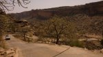
After picking up our Malian visas and an assortment of food we headed south filled with excitement and anticipation of our first park. When your new in country you need a little time to adjust to your surroundings, the climate, language difficulties but more importantly for overlander’s are road conditions. Driving into po´ after six hours of diversions, potholes, corrugations, dirt roads and toll booths we couldn’t find the piste we needed to get to Nazinga Ranch. We drove through po´ down to the Ghana border. Back to po´ we missed the junction three or four times. Asking locals proved fruitless as we would discover a lot on this trip, not many people had heard of the National Parks. As we approached our last option a few of the graders doing roadworks on the main drag moved forward revealing a sign, ‘Leo’. Making our way through the ramshackle market the dirt road soon opened out to the piste and we were on our way to Nazinga Ranch, we had only wasted some three hours.


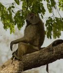
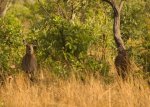
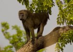
Baboon taking in some midday shade
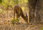
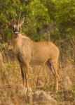
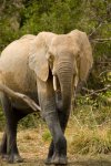
Nazinga Ranch was established in 1979 by a couple of Canadians for wildlife and ecological studies. They developed a 600km network of pistes interlinked with a number of barrages (watering holes/lakes) over a 50 x 40km area. They re-introduced various species which had been poached from the area and worked with farmers to limit livestock in the parks boundaries. With much better resource management the park flourished and surpassed all expectations. Today the ranch is nationally owned and aimed at tourists. We spent the next two days here mapping the remaining pistes and waypointing barrages taking in the plethora of wildlife as we went. What a welcome to Burkina Faso.

Our elation didn’t last long as the straight six pulling our 3.5 tonne Land Cruiser along started to lose power and we were soon reduced to a limp. Air/fuel were the suspect, but there was nothing obvious. We left the park via the west where we passed some of the most remote villages of our trip, a truly unforgetable experience. Struggling for fuel at Leo (3 stations closed down) we had to head off our scheduled route which was a cross country one to Deux Bales National Park and head back north to Sapouy. Arriving on vapour we were glad to see they had petrol, we filled up and as the truck had gotten worse decided we needed to be back in Oauga(dougou) to effect a repair., we had no choice.
")
")
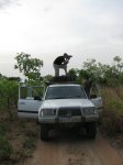
It was then we noticed the massive fuel leak as the sun set on Sapouy. Over the weekend we managed to patch the hole in the top of the fuel tank and also cleaned the air filters out. Checking and cleaned the spark plugs we could see no obvious problem, we traced the fuel lines, blew out the fuel filter, nothing. We would have to wait till Monday for Africa Motors to take a look. We headed up there early, they suggested a number of things none of which solved the problem although the problem did ease and the Cruiser was drivable when it had warmed up as long as you didn’t need to give it the beans at any point which made overtaking a little trickier than standard.
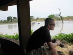
The next morning we arrived at Deux Bales National Park where the park ranger kindly informed us we would see nothing here. He was still happy to charge the 12,000CFA for the privilege of driving around though. We mapped the pistes, way-pointed the entrance, park boundary, park office and all the oued crossings which were extensive. Stomaches rumbled and the midday sun loomed so we headed off to the encampment which was under development after floods ravaged the area in 2006. Luckily the restaurant was up and running so we had a bite to eat overlooking the River Mouhoun where a man in a dugout canoe drifted silently past.
")
")
As the intensity of the oppressive heat waned we set off an covered another quarter of the park. We had seen nothing all day but elephant footprints. The day was drawing to a close and we stopped four or five times to check the wasp population… I hate wasps. After a swift cook-up and processing the day’s data we got an early night. As I lay there I couldn’t help thinking that our tents might get trampled by the elusive elephants in the dead of night. I woke early, getting the coffee on as the sun rose along with the sound of the dawn chorus… immediately followed by wasps. Quickly striking camp we moved on and finished mapping the park heading back to Oauga for the night. On the way we picked up a trio of young Germans who were more impressionist than revolutionist and informed us that there had been rioting in Ouga only days ago. We soon discovered that all the shops, businesses and fuel stations had closed as premises got ransacked and vandalised. This was bad news for us, we needed fuel and food before heading for Mali. Things calmed down and shops slowly opened their doors, we stocked up on what we needed and headed out northwest the next day for the border.
Mali

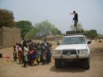
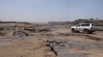
Raising a Sirocco as we headed westward into Mali
The border went better than expected with only a little hassle from the Gendarme (we drove straight past them as they laid about in the sun) and a struggle to get the carnet stamped at customs. We drove on late into the afternoon passing through the Bandiagara Escarpment… Dogon Country, what a place! We found a good camp-site and settled down for two nights fixing the fuel tank (again) as we had spotted yet another hole lower down. On the second day we tested our repair and then went off into Dogon to explore.
")
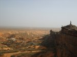
Bandiagara Escarpment – Overlooking the Sahel region of Mali and Burkina Faso beyond
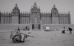
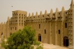
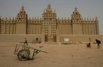
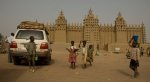
Time was tight as we wanted to visit the Grand Mosque in Djenne but news that we may not get into Senegal due to vehicle complications meant that we had to get to Bamako to ask the question there. This could change the rest of the trip. On the road to Severe late in the afternoon the 105 must have sucked some air into the fuel system (both fuel gauges did not work) and we ground to a halt. Changed the filter, drained the old one, cleaned it out, turned it over, nothing. Just when we thought the batteries would give it fired into life. Onward to Severe. The next morning we left early picking up fuel where we noticed another huge leak (again). Burning fuel we headed straight for Djenne on route to Bamako. Following the T4A maps we crawled tight past adobes, donkey carts, open sewers and the bustle of a market town. Pulling into the main square we were surrounded by the now familiar aggressive shouting squabble of sellers, hawkers, guides and would be guiders. We left them to take some photos and a young calmer chap approached us, another guide, but we liked his approach. ‘Bob’ was 22 and spoke excellent English, he would get us to the high spots for photo’s and speak to the Imam about letting us inside (not without some Baksheesh mind you). The Grand Mosque at Djenne is one of Africa’s greatest wonders and is the biggest Adobe (mud structure) in the world. It is the oldest City in Sub-Saharan Africa situated on an island surrounded by the Niger and Bani Rivers. Founded by merchants around 800AD, Djenne was Mali’s most important trading post in the 16th Century due its trade links with Timbuktu and location close to the salt and gold mines. Djenne has many Koranic schools (approximately 20) and attracts students from all over West Africa. It is also a pilgrimage site for many Muslims. The Mosque itself is made from sun baked mud bricks using a mud mortar with walls up to two foot thick in places. This helps the mosque stay cool as it can hold up to 3000 people!

It was a quick tour of the Mosque and surrounding town as we had to make a move to Bamako some 500km further south. Passing through sandstorms as the day grew darker we started to bare witness to a number of recent accidents. We grew tense, we had seen a lot of truck and car wreckage in Burkina Faso but these had mostly aged, showing signs that the accidents occurred some time previously. As we reached the City limits of Bamako we had several near misses in the darkness and drizzle including a near roll over and a moped spilling onto the asphalt right in front of us. Things improved slightly with the street lighting in the city but we found that both camp-sites on the outskirts closed. We had to find a cheap hotel, not easy when your tired and its now 2200.
The next morning while internet searching for the Senegalese Embassy we stumbled across the Sleeping Camel. An overlander’s hang out and camping spot in the heart of Bamako, it was only 400m from the Senegalese Embassy to. We had much to do so we checked out of the hotel and headed north to the Sleeping Camel. We dropped the vehicle off and proceeded on foot to the Embassy where, along the way, we got the usual harassment from a pair of street hawkers. The embassy visit proved favourable, we were given the go ahead that carnet is king and we would have no trouble. She still wouldn’t put it in writing for us though! Fingers crossed. The next thing on our list was a new fuel tank so off to Toyota to see what they could do… £840 and a three week wait, no thanks. Luckily a mechanic stepped in and showed us to a friends place where the mechanics promptly dropped the fuel tank, drained it, flushed it and began to braze up the 2 holes. Seeing an open flame glowing blue touching an open petrol fuel tank made me wince and hide behind the nearest wall, needless to say it didn’t explode and we were back up and running in no time.
Eager to get out of the city and back on the road again we forgot to pick up food supplies and left Bamako early heading for Baoule National Park. Boucle du Baoule NP occupies a huge expanse of area, certainly the biggest park on our list some 2,500,000 hectares Northwest of Bamako. The park was designated a UNESCO site in 1982, but all the large mammals have been hunted here and again there is nothing left. Guide books stated that there were three encampments and the piste was rough. It also said to enter from the south. Baoule is bordered to the north, south and east by national highways, but to pass through covers some 200km of dirt roads, cart tracks, hamlets and nothing else. We had to map this park taking all main junctions, main passable routes and tracing them to their destination or more commonly dead ends. Our main problem was not knowing to location of a fuel station on the southern highway once we reached it. Kita to Bamako is a 200km open stretch of road. Would there be fuel? Where would we exit? Would we even be able to exit? We had to keep our eye on fuel consumption and distance.
")
Because of this we decided due to range restrictions placed on us by the fuel we would resupply at Djema then retrace our path back some 10km and follow a piste south into the park from there, this would ensure we were at full capacity before entering the park. Getting fuel here was difficult, only one station had petrol as all the big trucks, minibuses and taxi’s here run on diesel. The owner was reluctant to sell us any as it serves the local population of mopeds. We managed to squeeze some 40 litres out of him, at a premium of course. It should be noted at this stage that we were using a combination of the T4A maps on GPS and the Reisse series of paper maps for West Africa. As we were on uncharted ground (most of the time) the T4A maps didn’t prove too helpful, only the bearings, distance calcs and waypoints were of much use. The Reisse maps also seem to have been taken from old French IGN (International Geographic National?) maps which were produced in the earlier part of the 20th Century, so therefore the finer details of dirt tracks, secondary pistes and roads in general were not always present and correct.
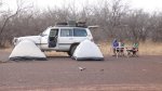
With fingers crossed we descended into Baoule late afternoon following a good vehicle width piste south until we came across our first village, navigating a way around with the help of some villagers we continued on the ever narrowing piste which we soon discovered the cause of, donkey carts. We stopped to let a caravan of trading carts through, the owners shy in our presence. After turning around at a number of dead end tracks we found the one we wanted heading directly south. Crossing the River Baoule (which was luckily dry as it was around 200m wide) we had entered the park boundary. On exiting the other side we came across a group of three men with donkey carts who were settling in for the night. We stopped and they walked over very wary and curious. They spoke no French, only local dialect. We gave each one in turn a small parcel of coffee and sugar for which they seemed very grateful if a little perplexed. Not wanting to impose we shook hands, exchanged smiles and headed on, making camp just a few kilometres away.
")
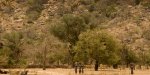
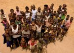
Pushing on south we were looking for a piste east which would bring us around into the centre of the park. Each track we took got narrower and the only traffic we saw were bicycles and one or two mopeds, skirting past small villages we drove through some tight bush which must have only been used by two wheels, we pressed on. Getting even more remote the villages turned to hamlets with only a handful of families working the arable land. Elders hide inside their straw huts shying away from us even though we were still some 300m away. With no distinct path through, we headed back southwest in the hope of picking up a better track. Hours went by as we slowly traversed the increasingly dense bush pushing through steep oued crossings. Eventually we came out of the park and picked up a small track which took us into another village. Over a year after visiting this village I still remember it so vividly. We asked around in French for directions out of their village and a way south. Met with blank stares and curious looks we tried to navigate the wide Land Cruiser through the tight settlement never designed for any form of vehicle. Eventually we stopped and produced a map. Surrounded by curious onlookers they did not understand what we were doing or even I wondered, what a ‘map’ was. A couple of the older kids were standing close so I started to repeat some of the village names off the map in the direction we wanted to go. If they have no perception of compass bearing or maps they surely know the names of local villages as they trade with them. I started with ‘Kita?’ Some 125km away. Nothing, silence. The entire village was out around us at this point listening intently. ‘Eremokono?’ around 50km away. Nothing, silence. ‘Moro-Moro’? The whole village erupted repeating ‘Moro-Moro!’ over and over and running in the direction we needed to go gesturing to follow them. They moved by hand huge piles of firewood stockpiled next to mud huts as I tried to navigate the Cruiser through. Simon was on foot walking through the village in front of the Cruiser as it crawled onwards. We stopped at the end of the village to thank everyone and I took the opportunity to take a picture from the roof-rack of the village out to greet us. A truly sublime moment.
")
")
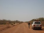
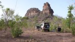
Pushing on to map Bafing Biosphere Reserve we again found ourselves on remote tracks that became almost none existent foot and bicycle paths and we found the ruins of the Chimp Sanctuary that looked like it had been closed for decades. This area of Mali is a low lying level plateau which is scattered with large 100-200m high sandstone stacks . Late in the day we found ourselves again questioning the reliability of the Land Cruiser due to it still leaking fuel and a now prominent vibration and transmission backlash. We were over 100km from the nearest piece of asphalt and well over 300km from the nearest known fuel source yet we were still forging a path south deeper and deeper into the reserve. We pulled over to wildcamp after passing through several remote villages and decided that we would return back the way we came the next morning. It was a real shame as this part of Mali is truly beautiful and very remote.
")
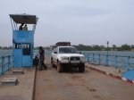
Once back on Asphalt and heading north we had to drive across the railway bridge at Mahina in between trains, got ripped off on a ferry crossing and swam in the River Senegal while the ambient temperature rose over 50°c . Overnighting in Kayes we headed off the next morning for Senegal at the Kidira crossing.
Senegal
There was a mix up at the border crossing, there I said it. To this day I still cant recall what we were actually thinking or exactly how it happened. The number one rule of overlanding… always ensure your paperwork is in order. We skipped past about 100 trucks queued up on the embankment road and followed the GPS directly to the Mali custom building. It was busy but we managed to get the carnet stamped ‘out’ of Mali. We asked about our passports and we were waved on. We found a gap in the road and carried on driving, we crossed the River and found what looked to be the Senegal side of customs, we queued up and got out passports sorted, we asked about the carnet and they waved us onward again so we drove off. About 2 miles down the road we realised that we must have missed it, taken a wrong turn etc etc. so we turned back, went back to the passport stamping place and they directed us to the local police station where we awoke a man who was not impressed to be seeing us. He looked at our passport and carnet, did some stamping and signalled for us to go. Now I’m not sure what happened here (or even previously!) but somehow we managed to leave this chaos without the Carnet being stamped. I think it was due to the chaos of just getting our passports done we ‘forgot’ about the vehicle. This all happened over a few hours in the mornings fighting the parked up trucks, queues, street hawkers, unhelpful customs staff, bureaucracy, rubber stamps and ramshackle buildings that showed no indication of if they were customs, police, the local bakery or someone’s residence. Whatever happened our passports were not stamped out of Mali and the vehicle was not stamped into Senegal! We drove on, heading Northwest in a poorly vehicle, tired and unsure what to do about the Carnet. We pulled off the main road to wildcamp that night and relaxed in the glow of the setting sun.
")
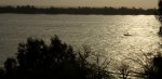
Sun setting over the Langue de Barberie taken from the lookout tower at the Zebrabar
We arrived at the Zebra Bar near St. Louis the following afternoon and met Martin and his wife. They have lived here for quite some time and set-up this overlanders haven on the Senegalese coastline. Martin has his own workshop for vehicles and employs locals to to work in the kitchen to supply campers or guests (they have a number of small accommodation blocks) with some tasty meals or snacks. We sheepishly told them about our Carnet… They couldn’t believe it and explained in detail what would happen if we got caught. They advised us to head to the main customs/police in St. Loius to try and get it sorted there. They called ahead for us as they knew them very well.
Unsure what would happen, turns out, the (almost) worst, we got pulled by a ‘short man syndrome’ angry little policeman. We indicated, pulled over. He asked us to pull over some more further into the verge. Calmly he asked for Simon’s IDP (International Driving Permit) then tried to bribe/fine us because we didn’t indicate the 2nd time when pulling further onto the verge. We argued, nothing. I told Simon to give him the $5 because if he asked for more paperwork we would be screwed. We paid him and drove off. Our 1st bribe paid in 4 weeks. Remarkably we didn’t get stopped again and made it all the way into St. Louis. We found the customs place and they were very helpful but didn’t fully understand how this had happened and why we drove the nearly 1000 miles directly across the country to where we were all now sitting (we couldn’t explain that either). Eventually we got a piece of paper stating that the customs border at Diema would issue a 3 day ‘passavant’ to get our Carnet in order and were advised to go to Dakar to do this. We drove back to the Zebrabar and got stopped another 3 times just trying to get out of St. Louis.
We left the Zebrabar the next day for the border at Diama to see if they would stamp our paperwork. It was less than 100 miles to the north but seemed to take a long time in a poorly Land cruiser. After an hour of pigeon conversation overlooking the Mauritanian desert we managed to ‘blame’ the customs guys on the Senegalese side for not stamping our carnet. He looked at us out of the corner of his eye, almost not believing us but as we had this ‘piece of paper’ he magicked up the 3 day passavant (at a cost). With a sigh of relief we returned to the zebrabar with the good news (after being stopped 6 times through St. Louis). We spent the rest of the day looking at the fuel tank leaks and taking the front propshaft off as the UJ was completely destroyed. How we had got it this far I will never know.
We headed for Dakar the following morning in the darkness that is 5am, taking the main routes south with difflock engaged. With worries of winding up the transmission we took every opportunity to disengage, coast along and re-engage which usually happened at the numerous speed bumps entering and exiting every village and town along the route. Entering Dakar we managed to hit rush hour and had to battle our way through to the port. We stopped at a number of locations trying to get someone to recognise what we were here to do but just got passed around. Some didn’t seem to have the right ‘rubber stamp’. Eventually a young chap said he knew where to go and hopped in the back of the Toyota, he was on the phone for most of the time and giving us directions. Turns out he was picking up what we think was his dad. So he dives in the Toyota to among our bags, photography gear, laptops and satellite broadband unit. This older gentleman was shouting and gesturing with a general African tone of aggression. We told him to calm down or get out but he didn’t seem to understand. Either way he found us the man we needed to speak to and got us in there to see him pretty sharp. He spoke on our behalf and we have no idea what was said but the right rubber stamp emerged from the top right drawer of his desk and in slow motion began to stamp the triplicate page for the temporary import of our vehicle into Senegal. A wave of relief and $40 to the aggressive man who wanted $200 and it was onto challenge number two… Propshaft UJ.
It was lunchtime in Dakar and we decided to stop and eat 1st before heading to the main dealer. I’m giving this a mention here because it was some of the best roadside food we had eaten in all of West Africa. It was a little café next to the port run by a lone Senegalese women with only 5-6 tables inside. The food was exceptional and came in what I would describe as a ‘western portion’ it was enough to fill you. Some places we had visited we had to order our meal twice to the disbelief of the staff as it just wasn’t enough. Suitably filled with sustenance and a glimmer of hope we set off for the Toyota main dealer. Closed for lunch or whatever from 11am to 2pm giving us a brief window of 2 hours before they closed at 4pm. It took 2 hours and 7 ‘windows’ to get the UJ and persuade them to press it into the Propshaft for us. They wouldn’t however refit it as it was 3.45pm and they wanted to close so we refitted it ourselves in their car park much to the annoyance of the gun touting security guard telling us to leave while we swore at him from under the vehicle. Finally fitted we were done, where to now? Find a camp site outside Dakar. 2 lanes in Dakar turn into 6 at rush hour and everything grinds to a halt. It took 3 hours to drive the 20 or 30 miles out of Dakar to the main road by which time it was dark and it had been an extremely long day with only a little rest. Worn down by this we decided the only hope we had was to head back to the Zebrabar so that is what we did, driving through the night to get to this overlanders haven for the next day where we could relax. Arriving at midnight we quietly opened the main gate and drove in parking back up exactly where we left earlier that day before putting up the tents and crashing out. It was our longest day having driven for some 14 hours and covering over 600 miles and the rest of the time spent arguing with everything standing in our way.
The other reason of course for heading back north was that we still needed to map two national parks. The parks in Senegal are generally bird sanctuaries as this area is depended on by migrating birds from all over the world. We would have to map these parks in a different way because there was very little to drive. Mapping generally involved taking the hand-held GPS and waypointing all important features and then tracking the boats, pirogues, vessels etc that we were travelling on along the waterways. This was kind of a nice break for us as we could leave the truck and relax as we had no control over where our guides and drivers steered us.
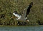
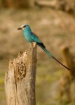
The 1st of 2 parks in the north of Senegal is The Langue de Barbarie. It is right by the Zebra Bar and it is easy to get a local boat trip (Pirogue) with guide right from the shoreline. We mapped the entrance and then the walk to the boat and carried the GPS onto the narrow vessel. Our guide was an enthusiastic young chap who grew up in the area. We saw plenty of bird life over the next 45 minutes which included turns, pelicans and a distant Osprey (so we were told). The Langue is a thin sandy peninsula which shields the mainland from the Atlantic Ocean and provides a haven for migrating sea birds.
")
Guided pirogue trip along the coastline
The 2nd park which needed mapping was Djoudj National Bird Sanctuary so the next day after a leisurely breakfast we headed off in that direction. To get there we had to pass back through St. Loius and got stopped no less than 6 times! Within 50km of our turn-off there was a clunk and a scrape… The main fuel tank had just sheered its cradle brackets and the nose of the tank which was nearly full was ploughing a line in the graded gravel road. We pulled over to take a look. The tank seemed OK but the bracket was toast. With some ingenuity and the use of a ratchet strap we managed to secure the tank enough to get back to the Zebra Bar. On the way through St Louis we had the cradle welded up and picked up the bolts and bits we needed to fix it. After being stopped another 4 times we made it back to camp and got on with the repair and spent the rest of the afternoon not really doing much.
Over the previous few days we got chatting to a group of American girls who were also staying at the Zebra Bar. Most evenings we would eat and drink together discussing travelling, politics, religion… the usual. As they didn’t have their own transport we offered them the 3 seats in the back of the Land Cruiser and the chance to come and visit the Djoudj Bird Sanctuary with us (and to also see exactly what we were doing). The added advantage of this was having a female presence, as the police no longer seemed interested in holding us up for any length of time. They also spoke better French than both of us combined.
Djoudj National Bird Sanctuary is situated in the Senegal River delta near the Mauritanian border and is a wetland of 16,000 ha. There is one main large lake surrounded by streams, ponds and backwaters. It forms a living but fragile sanctuary for some 1.5 million birds and the forests and grasslands hold species typical of the Sahelian zone of Africa.
The park was mainly established as the area is so important for birds, supporting 3 million waterfowl, and is one of the main West African sanctuaries for Palaearctic migrants. It is one of the first fresh water sources they reach after crossing 200km of the Sahara. From September to April, an estimated 3 million migrants pass through, including garganey, shoveler, ruff, pintail and black-tailed godwit. Thousands of flamingo nest here regularly as well as 5,000 white pelican, white-faced tree duck, fulvus tree duck, spur-winged goose, purple heron, night heron, various egrets, spoonbill, African darter, common cormorant and Sudan bustard. Mammals include warthog and West African manatee, and several species of crocodile and gazelle have been successfully reintroduced into the area. But this wildlife haven is threatened from many sides. Agricultural chemicals are finding their way into the once-pristine waters of the Senegal River thus disturbing delicate links in the food chain, and a dam is being built which will disturb the annual wet-dry cycles that have brought life to Djoudj. A study sponsored by the World Heritage Committee has reported on the measures required to ameliorate the effects of the dam through an inexpensive series of dikes and sluice-gates and a carefully timed release of the life-bringing waters. It is hoped that the World Heritage status of Djoudj will help convince the government of Senegal to take the necessary measures and that tourism will take notice from the work of the MAPA Project.

We got the park and booked ourselves on the next boat trip out along the backwaters logging the tracks and waypointing along the way. We took the GPS and cameras onto the wide and open boat as we headed off away from land for the next hour or two. The backwaters were lined with tall grass which harboured a number of crocodiles and a couple of Nile Monitor Lizards.
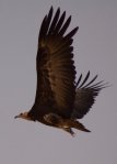
We spotted the usual wetland birds along with a fishing eagle in the distance. At the end of the boat trip and that route safely logged we went for a drive around the main lake following every possible route we could see. We found a number of hides tucked away in trees overlooking predominantly dry lakes. We visited the one large lake which had dramatically decreased in size and we could just make out the pink flamingos in the distance. We followed bumpy tracks and trails for most of the afternoon and then called it a day heading back to what we now referred to as ‘base camp’. Processing our data for the day and sending it across to March in South Africa we rewarded ourselves with a few beers before bed.The plan from here was fairly straightforward as the Project had more or less come to an end. Team 2 by this time had made their way through Sierra Leone, Liberia and Guinea and would pick up the parks in the Gambia on their way through to Dakar. There was one more small reserve south of Dakar on the coast at Popenguine. It was agreed that we would head down there and map that and rendezvous with Team 2 in Dakar over the next few days. Seb and Chris knew a few friends from University working for the UN in Dakar so had their accommodation and contacts sorted.
Popenguine is a small coastal village populated by ex-pat ‘artists’ which has a small nature reserve just to the south of the village adjacent to the coast. This is the first and only park in Senegal managed by the National Park Service in partnership with the local women’s group, RFPPN. It is only possible to hike through the 2493 acre park as there are no routes for vehicles. Landmarks include the Cap de Naz, the lagoon for bird observation and a number of concrete WWII bunkers/gun emplacements. We spend the afternoon walking around and track logging our route, we climbed to the top of the cliffs and scrambled around the gun emplacements before heading back to the truck. We spent that night in a local camp site which had a great pool and was right on the beach.
")
Relaxing back at the camp site on the coast
The last few remaining days of the trip were spent in Dakar clearing out the truck, backing up MAPA data off both laptops and GPS systems, arranging for the kit to be returned to South Africa and containerising the two trucks. We also managed a bit of sight seeing. We spent a lot of time with Seb and Chris and their friend Dale in his apartment complex in Dakar. We ate well with an evening of Braai tuna steaks and eating out in some great coastal restaurants the rest of the time.We left our 105 with Seb to finalise the container shipment back to Durban and got a taxi to the airport early in the morning. Our flight plans were Dakar to Casablanca (Morocco) and eventually Heathrow where Lisa and Edwina met us at Terminal 5. Our once in a lifetime mapping project had come to its eventual end.
Epilogue
5 weeks out in West Africa still felt like a very long time even when we were 2 weeks in. The mapping part of our expedition went very well and was, for me at least, enjoyable. Probably the most pertinent aspect of the expedition was the ill health of the truck in general. The vehicle had been driven by previous volunteers all the way from South Africa up the west coast route through Angola, DRC, Congo, Cameroon, Nigeria, Togo, Benin etc. and hadn’t been serviced well by limited facilities in these countries. It had been driven hard for nearly a year prior to it landing in our hands. Everyday we had to nurse it along in one way or another and the fuel leaks never went away. It was a constant worry and reminder day in day out.
As an expedition with a purpose the mapping of these National Parks allowed us, pushed us even to go further and deeper into blank spaces on the map. If this was a regular overland journey we would probably have turned around long before we got to where we did. Driven by this need to map these parks we passed through some truly remote villages, saw some exceptional landscapes and brought a new definition to the term ‘wild camp’.
Without the MAPA Project and Tracks 4 Africa we would never have had this opportunity and for that I (and I am sure I speak for Simon to) am truly Grateful. It goes to show, if you see am opportunity for something you want to do, go for it. No matter if the details are unknown or the dates ‘don’t fit’, lodge your enthusiasm.
My Grandad past away a week prior to our departure and I felt terrible leaving my family behind. We were mapping Deux Bales NP in Burkina Faso at the time of his funeral (which Lisa attended in my place) at which point we stopped driving so I could honour his passing. The expedition as a whole, for me, is a tribute to him and I will always associate this trip and my love of Africa with him.
-
- Baboon taking in some midday shade
-
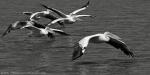
- Migrating Pelicans – Djudj NP, Senegal

-
- Raising a Sirocco as we headed westward into Mali
-
- Bandiagara Escarpment – Overlooking the Sahel region of Mali and Burkina Faso beyond
-
- Cruising out of ‘Ouaga
-
- Sun setting over the Langue de Barberie taken from the lookout tower at the Zebrabar
-
- Guided pirogue trip along the coastline
-
- Relaxing back at the camp site on the coast

2 responses
Leave us a message
Buy us a Coffee?


Thank you for the writeup and the pictures!
It is a big inspiration to us, because we will leave switzerland at the 13 November – and drove in direction south africa over the west.
02/11/2012 at 09:48
Thanks Stefan, It took a while but it was worth it! How is Mali looking these days? Is there still trouble there? Hopefully your route will be trouble free. Be sure to stop off at the Sleeping Camel in Bamako and say hi to Mark 🙂 also Martyn and Ursula at the Zebra Bar in Senegal. Both excellent stops on your route South. Good luck and let us know how you get on crossing the DRC and Angola, Its a route I have always wanted to do.
02/11/2012 at 11:17